
Map 1: Predicted temperature anomaly at the level of 850 hPa (1500 m) for July 29, 2021
Starting next Tuesday (27), an intense mass of polar air will begin its advance towards Brazil. The following days will show exceptionally low temperatures, snow and the prospect of very cold days for a longer period than usual for the south of Brazil. For the Midwest and Southeast regions there are chances of frost, while for the Amazon region, temperatures will drop significantly.
This intense mass of cold air will originate near the British Halley station, south of the Weddell Sea in Antarctica. This station draws attention because it has registered several records (see WEC news) for monthly cold temperatures, as occurred in January, June and probably in July this year as well; in general, the Weddell Sea has temperatures below average and strong winds towards South America this year.
Throughout the 28th, once the cold air mass crosses the Drake Passage, it will follow a more continental sector through Patagonia, which will help maintain its cool and dry character supported by a 1035 hPa high pressure system.
On Thursday (the 29th), the cold air also is expected to spread over the rest of the Center-South region of Brazil, causing intense cold in Goiás, Mato Grosso and western Minas Gerais.
During the 30th and 31st days, the cold air will advance towards the Amazon, dropping temperatures in normally hot states like Acre and Rondônia.
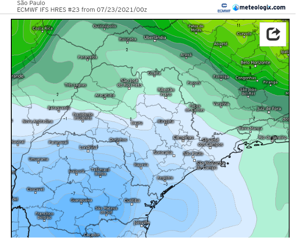
Some meteorological models indicate that minimum temperatures of -10ºC to -12ºC may occur in the highest points of southern Brazil as well as broad frosts that may affect the states of São Paulo, Minas Gerais and Mato Grosso do Sul.
Map 2: Predicted temperature anomaly at the level of 850 hPa (1500 m) for July 30, 2021
Air masses like this, which are characterized by exceptionally cold temperatures which persist for a long time, are rarely seen. It is noteworthy that the models have indicated very low values (< 0°C or 32°F) at the level of 850 hPa not only at the initial influx of cold air, for one or two days as usually occurs, but for the Wednesday (the 28th) until Saturday (the 31st) period of the next week, that is, for several days in a row.
The impact of this cold wave could be huge, especially for the crops of coffee, sugar cane, wheat, corn, oranges and vegetables, which have already suffered from the frosts recorded in late July and also in July this year.
Atlanta, July 25, 2021
By M. Romão and L.B.M.Pires